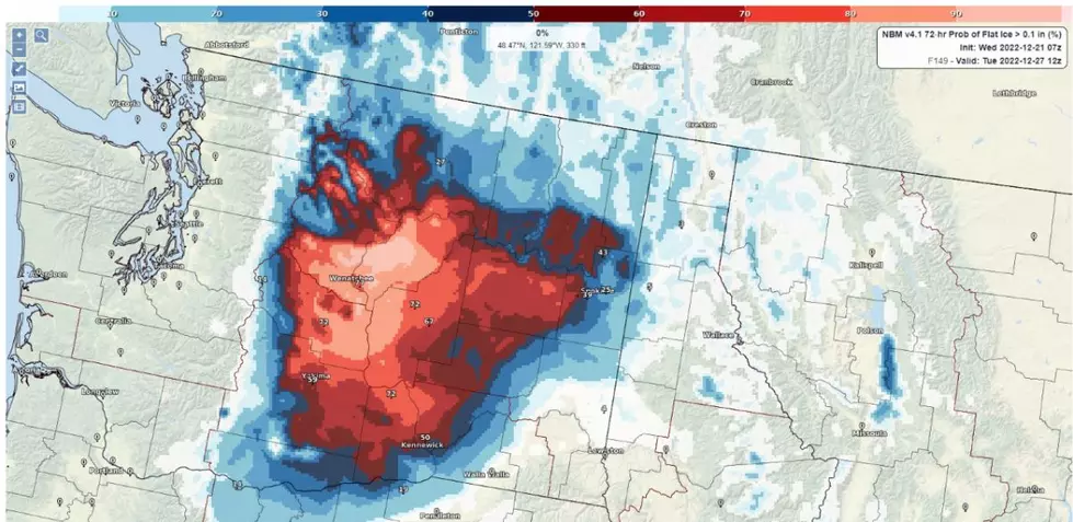
Freezing Rain Coming to Wenatchee Valley This Weekend
Expect temperatures to drop to dangerous levels starting Thursday, before seeing icy weather conditions this weekend.
National Weather Service Meteorologist Steven Van Horen says wind gusts near the Waterville Plateau are expected to bring in temperatures as low as -35 degrees.
“[People] could see frostbite setting in within 10 minutes on exposed skin, so make sure to wear appropriate clothing,” Horen said.
On Friday, temperatures are expected to increase along with some incoming snow and freezing rain for the holiday weekend.
Travel conditions are expected to be hazardous with slick and icy roads. Drivers should prepare for longer than normal commute times this weekend.
By Monday, temperatures will be brought up above freezing, which may result in flooding and increased slush for the rest of the week.
“The main thing that we'll be looking at with the warmer weather and the rain will be some localized flooding impacts in the low lying areas,” Horen said. “Because there's so much snow in the valleys, I could see some of that melting off and getting some puddles forming. That will be something that we'll be watching for as we go into next week.”
More From 610 KONA