Oregon Snowpack Takes A Step Backwards From December
Some basins have seen a drop, percentage wise, in their snowpack from December to this month. Most of that decrease occurring in western Oregon.
So, why the drop?
“So, we have been seeing some warmer temperatures in comparison to what we had in November and December," noted Matt Warbritton is with NRCS Oregon. "But we're just getting not as much storm impacts in those parts of the state like the southern basins east of the Cascades crest are seeing.”
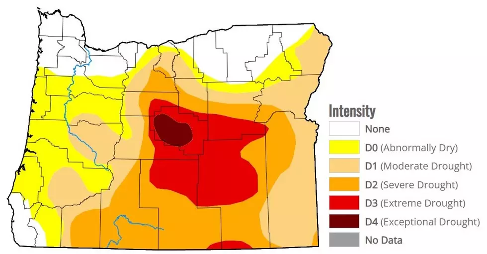
Warbritton noted some of the strongest snowpacks right now, are in the SE corner of the state. When it comes to basin averages across the state:
- Upper Deschutes, Cooked: 109% of average
- Willamette: 104% of average
- Rogue, Umpqua: 106% of average
- Klamath: 128% of average
- Lake County, Goose Lake: 165% of average
- Hood, Sandy, Lower Deschutes: 120% of average
- John Day 120% of average
- Harney: 176% of average
- Owyhee: 158% of average
- Malheur: 106% of average
- Umatilla, Walla Walla, Willow: 113% of average
- Grande Ronde, Powder, Burnt, Imnaha: 117% of average
While these numbers are encouraging for the spring and summer ahead, Warbritton noted a few good storms will not be enough to snap the multiyear drought central and southern Oregon have experienced.
“Like we saw last year, you know, we had these large storm events towards the end of December and into early January. So what we really want this year is for this snow and precipitation to keep accumulating, throughout January, throughout February, and throughout March. We really don't want to see any dry periods, even a week or two. We really want to see consistent healthy build up so we have normal to above normal stream flow conditions during the summer.”
If you have a story idea for the PNW Ag Network, call (509) 547-9791, or e-mail glenn.vaagen@townsquaremedia.com
More From 610 KONA